If you hike regularly, you have probably come across GPX and KML files when planning routes or downloading tracks. These files are essential tools for modern hiking navigation, especially if you like to explore new trails or go on multi-day hikes.
In this guide, we explain the difference between GPX and KML files, how to use them, and why we recommend Organic Maps as one of the best offline navigation apps for hiking and outdoor adventures.
What are GPX and KML files?
GPX files are a standard format used to store coordinates for a route. They are widely supported by almost all GPS devices, map software, and navigation apps.
In general, most navigation apps support importing a GPX file to follow a route. Popular apps like Strava, Garmin, AllTrails, and Wikiloc all work with GPX. Many of these apps also act as social networks, where you can share your own hikes and discover routes from other hikers.
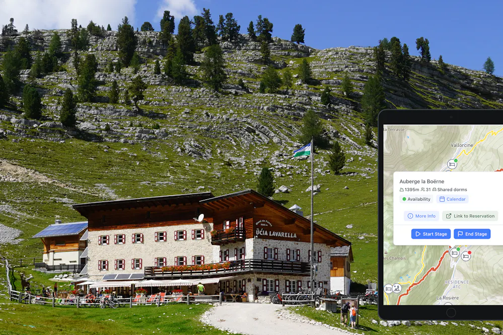
KML files, on the other hand, can store much more than just geographical data. They also support text, colors, icons, and different layers of information. Because of that, KML files are perfect for managing points of interest like mountain huts, campsites, water sources, mountain passes, or viewpoints.
With KML, you can add names, short descriptions, and different icons or colors for each point. This makes the map much easier to read and helps you quickly understand what each point represents when you are on the trail.
Why we recommend Organic Maps for navigation
While many apps can be used for hiking navigation, Organic Maps is our favorite choice, especially for long-distance hikes. It combines everything we look for on the trail: it is free, supports GPX and KML files, and works completely offline.
The app has a clean and easy-to-read map interface, with useful outdoor layers like hiking trails and contour lines. It is also optimized for low battery usage, which is a big advantage when you are hiking for several days and do not have regular access to power.
But the best feature, by far, is offline maps. You can download all the map data for a specific region in advance. Once you are on the trail, even with no mobile signal or internet coverage, everything still works perfectly because all the information is stored on your phone.
For multi-day hikes or remote areas, this is a real game changer.
How to import bookmarks and tracks in KML or GPX format
Organic Maps allows you to import tracks and bookmarks from other apps, as long as they are in KML or GPX format.
- Locate the shared KML or GPX file. This can be from an email, instant messenger, or cloud storage like Google Drive or iCloud
- Tap once, or tap and hold, on the file and choose Open with Organic Maps (Android) or Import with Organic Maps (iOS)
- The app will open and show the message “Bookmarks loaded successfully!”
- You can then find the tracks or points directly on the map or inside the Bookmarks section
Tip: it’s a good idea to organize your bookmarks by folder, especially if you are importing multiple stages or points of interest.
How to use the app offline
To use Organic Maps offline, you first need to download the regions you will be hiking through.
- Open Organic Maps while you are connected to the internet
- Zoom in on the area you want to download. Once you are close enough, the app will automatically suggest downloading the region
- Move along your full route and repeat this process, making sure all regions are downloaded
Some long hikes cross several map regions, so it is important to check the entire route in advance, not just the starting area.
Once everything is downloaded, you can access the map, your GPX tracks, and all waypoints fully offline. No mobile signal or Wi-Fi needed.
How to calculate the distance between two points on the map
You can also use Organic Maps to calculate distances, for example to your next hut, the end of the stage, or the summit.
- Select any point on the map and tap Route to. The app will create a route from your current location
- On the top bar, make sure the Walk option is selected
- If you do not want to use your current location as the starting point, select another point and tap Route from
This feature is very useful for checking remaining distance and elevation during the hike, especially when planning breaks or deciding how far you can still go before dark.
Using GPX and KML files can make your hikes safer, easier, and much more enjoyable. With the right navigation app, you can follow routes, mark important points like huts or water sources, and stay on track even in remote areas with no signal.
For us, Organic Maps is a simple and reliable choice for hiking navigation, especially for long-distance and multi-day routes. The app is free, open source, and developed by a small team that really cares about outdoor users. If you find it useful, consider making a donation through the app. It’s a nice way to support a project that helps us explore the mountains with confidence, even far from any internet connection.