Picture the typical scenario: you decide to hike the Alta Via 1 or Tour du Mont Blanc. The excitement is real. The commitment is there. Then comes the planning phase.
Suddenly, it's 11 PM. Fifteen browser tabs are open. There's a spreadsheet that started with good intentions three days ago. A Reddit thread from 2017 offers conflicting advice. Someone's blog post contradicts the guidebook. You are trying to figure out variants, accommodations, water sources, and camping regulations.
The information exists, people have walked these trails thousands of times. But finding everything in one place? Good luck with that.
That's exactly what Take a Hike decided to fix.
A different approach to Hike Planning
Take a Hike came from exactly this frustration. The creators: Julio, with over 15 years building websites and web apps, and Laura, who could spend hours deep in trail research and route planning, decided to build what kept missing from the market.
Laura's the type who examines maps for fun. Who debates variants over breakfast. Who genuinely enjoys figuring out the perfect stage breakdown. Julio had the tech skills to turn that obsession into something useful for others.
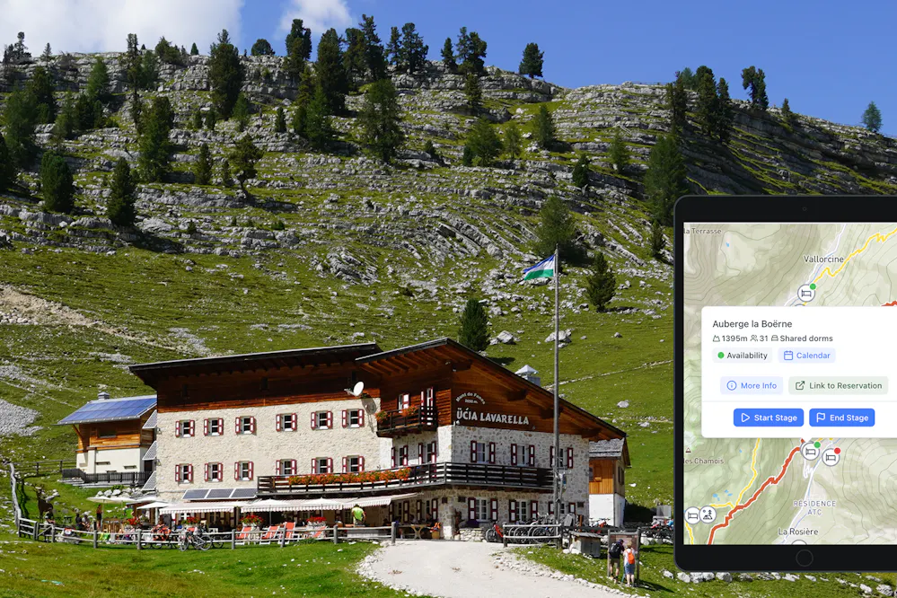
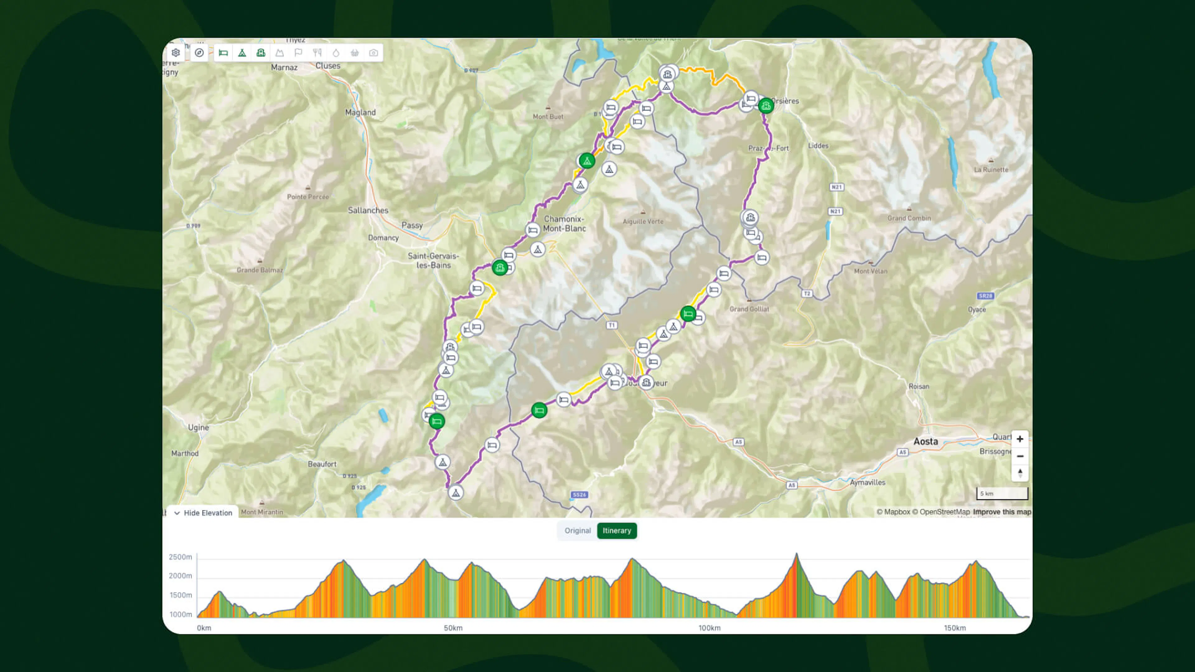
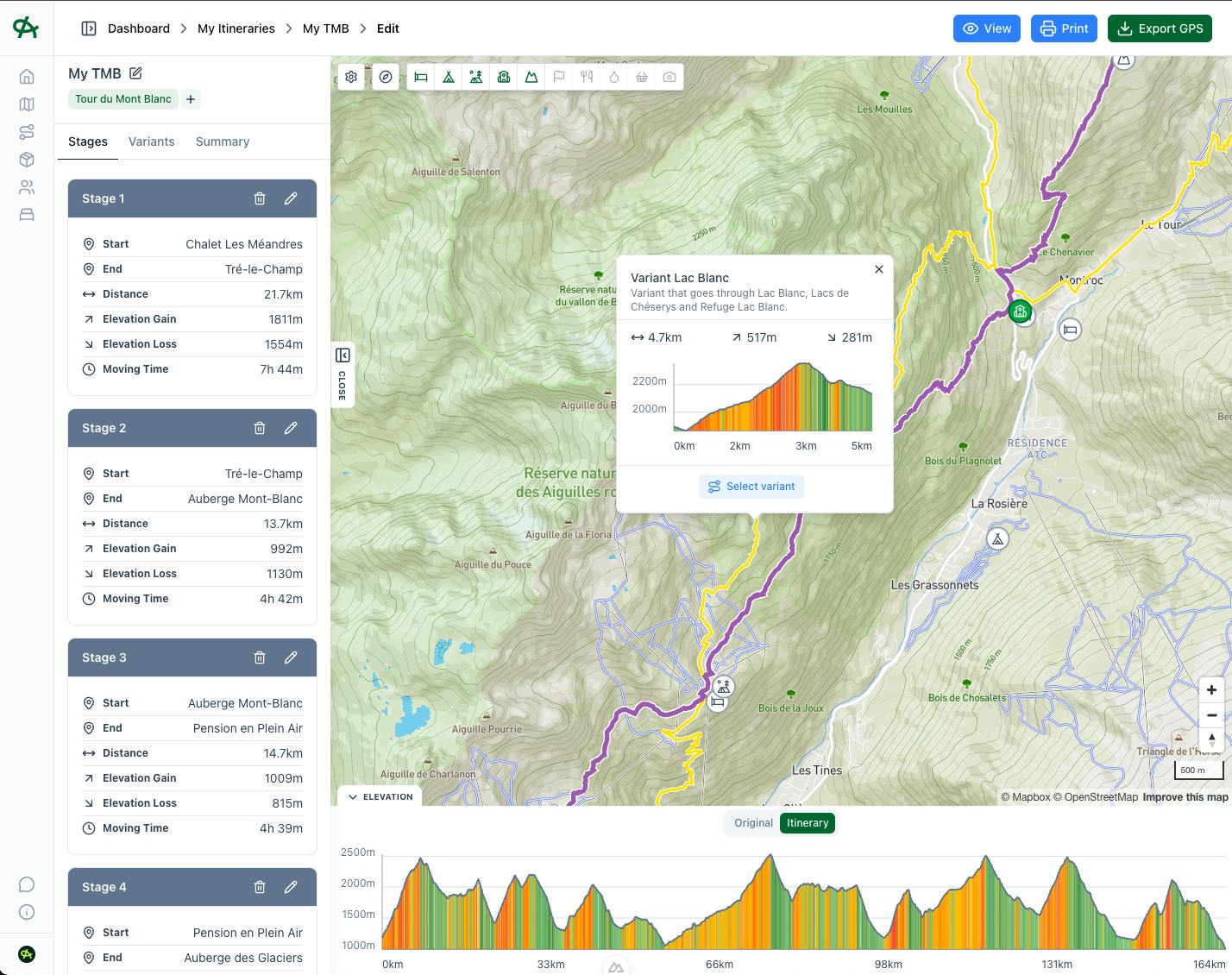
The result? A straightforward tool. One interactive map with everything needed for planning long-distance hikes. Routes verified by people who've actually walked them. Official variants with stats and descriptions. Mountain passes, refugios, campsites, water sources, all in one place.
No more spreadsheet chaos. No juggling between five different apps. Just clear information and flexible planning. You pick your hike, then you just start planning. Want to skip a stage? Go ahead. Prefer one variant over another? Easy. Need to start your day somewhere different? Click and adjust. Everything recalculates automatically.
Watch how it works
How the Planner actually works
Traditional guidebooks offer "standard" stages. Day 1, Day 2, Day 3. But hiking isn't standardised. Some hikers find certain stages too long. Others want to combine shorter days to maintain momentum. Take a Hike Planner accommodates individual pacing and preferences. Hikers design stages that match their fitness level, time constraints, and hiking style.
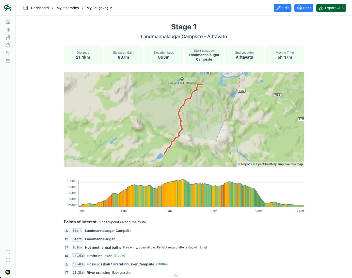
The interface is intentionally simple. Hikers choose where each day starts and ends. The planner displays precisely what that stage looks like: distance, elevation gain and estimated moving time.
When planning is complete, everything exports cleanly. GPX files work seamlessly with Garmin devices and navigation apps. Detailed PDFs include maps, elevation profiles, and custom notes. Everything needed for the trail.
The platform currently features hikes that have been thoroughly walked, tested, and mapped by the Take a Hike team. Each route includes verified information gathered from actual trail experience.
The tool handles the complexity behind the scenes, presenting hikers with clear choices and accurate information.
Create your perfect itinerary with our Hike Planner
Plan every stage of your hike with official routes, variants, and real-world trail data, all in one place.
- Curated hike data with official routes, variants, and more
- Design your hike stage by stage
- Find huts with real-time availability
- Download GPX files for your favorite navigation app
- Generate a printable PDF for your hike
What the Planner doesn't do
Setting clear expectations matters. This isn't a booking platform. The tool doesn't handle refugio or campsite reservations. Hikers still need to contact accommodations directly for bookings.
It's also not a navigation app. Hikers should continue using their trusted devices: Garmin, phone apps, whatever works on the trail. The planner simply provides clean GPX files compatible with these systems.
The tool won't make decisions either. Should hikers take the high route in favorable weather? That judgment call remains with them. The planner supplies information: distances, elevation changes, water source locations. Decision-making stays where it belongs, with the hiker.
Think of it as a comprehensive planning companion, not an on-trail guide.
Why it is a paid tool?
Creating accurate, detailed hiking maps requires significant time investment. Walking trails, verifying variants, checking refuge locations, assembling all the informations, this work takes months of dedication.
Unlocking specific hikes requires a one-time payment, starting from 20€. No subscriptions, no monthly fees. Purchase access to the Tour du Mont Blanc once, and that access remains permanent. All future updates to that route are included. And you can create as many itineraries as you need.
The pricing reflects a balance: keeping costs accessible while supporting continued development. New routes need verification. Existing routes require updates. The platform needs maintenance and improvement.
For hikers who appreciate thorough planning tools and want to support independent creators, the value proposition is straightforward.
Plan every stage of your hike with official routes, variants, and points of interest, all in one place.
Planning shouldn't be harder than hiking. Information should be consolidated, not scattered. Every hiker deserves to start their adventure with confidence and clear understanding.
Whether it's a first multi-day trek or the twentieth. Whether planning the Tour du Mont Blanc, Walker's Haute Route, or future routes yet to be mapped. The goal remains consistent: providing clear information, simple tools, and the freedom to design adventures that match individual goals and abilities.
This is what Take a Hike Planner offers. No more late-night tab marathons. No more spreadsheet confusion. Just straightforward planning for hikers who want to understand their routes before hitting the trail.